The trail becomes narrower thereon and takes you to to Deurali pass. Located at 3,000 m, it’s a high point, and from here you go down to the Tamur River. You stop for the night at a place called at Gurja (2,000 m), before reaching the river. Now, it’s all easy-going, the trail descending gradually for some hours before you arrive at Dobhan (640 m). You’ll be crossing a suspension bridge over the Matwa Khola on the way, which is also quite an experience!
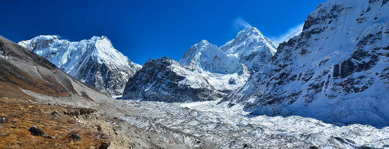
Having crossed the river, you continue hiking on a dirt track going slightly uphill along the banks, and reach Handrung about 35 minutes later. But now, you’ll find that the narrow is pretty slippery, and you got be careful. You’ll to be in Mitlung (800 m) some two hours later, and the next morning’s hike of about one hour will take you to Sinwa (980 m), and two-and-a-half hour later, you’ll be welcomed with a signboard reading: “Welcome to Kanchenjunga Conservation Area”. You’ll stop to have lunch at Chirwa (1,190 m), and then hike on to Tapethok (1 h, 1,320 m). After an hour more of easy hiking on a flat trail, you begin to ascend for some time before reaching Lelep (1,687 m). The next day, your fifth on the trail, starts with a 15-minute descent to a suspension bridge, followed by some more, and about two hours later, you’ll reach Jaubari, where a lovely waterfall will enchant you. Another hour or so later, the trail ascends steeply for an hour along a gorge to Amijlosa (2,498 m), and it’s pretty trying on the legs. However, you’ll be hiking sometimes up and sometimes down for the next three hours before coming to Gyabla (2,730 m). The next day, you walk downhill to Ghunsa Khola to reach Phole (3,080 m), and then on, Ghunsa (3,410 m), where you stop for a rest day to acclimatize yourself. On the eighth day, you hike for about three to four hours to reach Khambachen (4,145 m). As you continue going up, you’ll get your first sighting of Kumbhakarna (7,711 m), and reach Kambachen (4,145 m). Then on, the following morning, you trek to Lhonak (4,792 m), Pang Pema (5,140 m), and then return back to Khambachen again. On the way, you’ll see peaks like Khambachen (7,903 m), Kirant Chuli (7,365 m), Gimmigela Chuli (7,350), Pathibahara Khas (7,140 m), Nepal Peak (7,168 m) and Wedge Peak (6,802 m) and Taple Shikhar (6,447 m).
On the tenth day, the trek is for seven hours from Khambachen to Ghunsa and then to Selele (4,130 m), where you’ll get a view of Sele Pass (4,290 m). The next day, you trek to Tseram (3.138 m), walking through Sinelapche La pass (4,663 m) and Mirgin La pass (4,460 m), from where the views of Kanchenjunga (8,586 m), Talung (7,349 m), Kumbakarna (7,710 m), Rathong (6,682 m), Pholesobi Thongje (6,645 m), and Nyukla Lchun (6,012 m) are great. Then, it’s all downhill for some time, before going up again to Tseram, with Chachung Lake on the way.
The twelfth day takes you to Tortong (2,980 m) along the Yalung Glacier to Ramche (4.620 m) and Oktang (4,740 m), before returning to Tseram, and then to Tortong. The following morning begins with a descent through a forest, before ascending to Lasiya Bhanjyang (3,415 m), and then downhill to Yamphudin (1,690 m) where you spend the night. Come morning, and you’ll walk across a suspension bridge to reach Ghatichhinne Bhanjyang (2,157 m) and then Ekchana Bhanjyang (2,070 m), and Khebang (1,910 m). You carry on descending to Dobhan before climbing again to Khanidingbe and Dandagaon. The last day, you hike for half-an-hour downhill to Medibung , reaching civilization once again after two weeks of romping through the wilderness, and from where a bus takes you to Ilam.